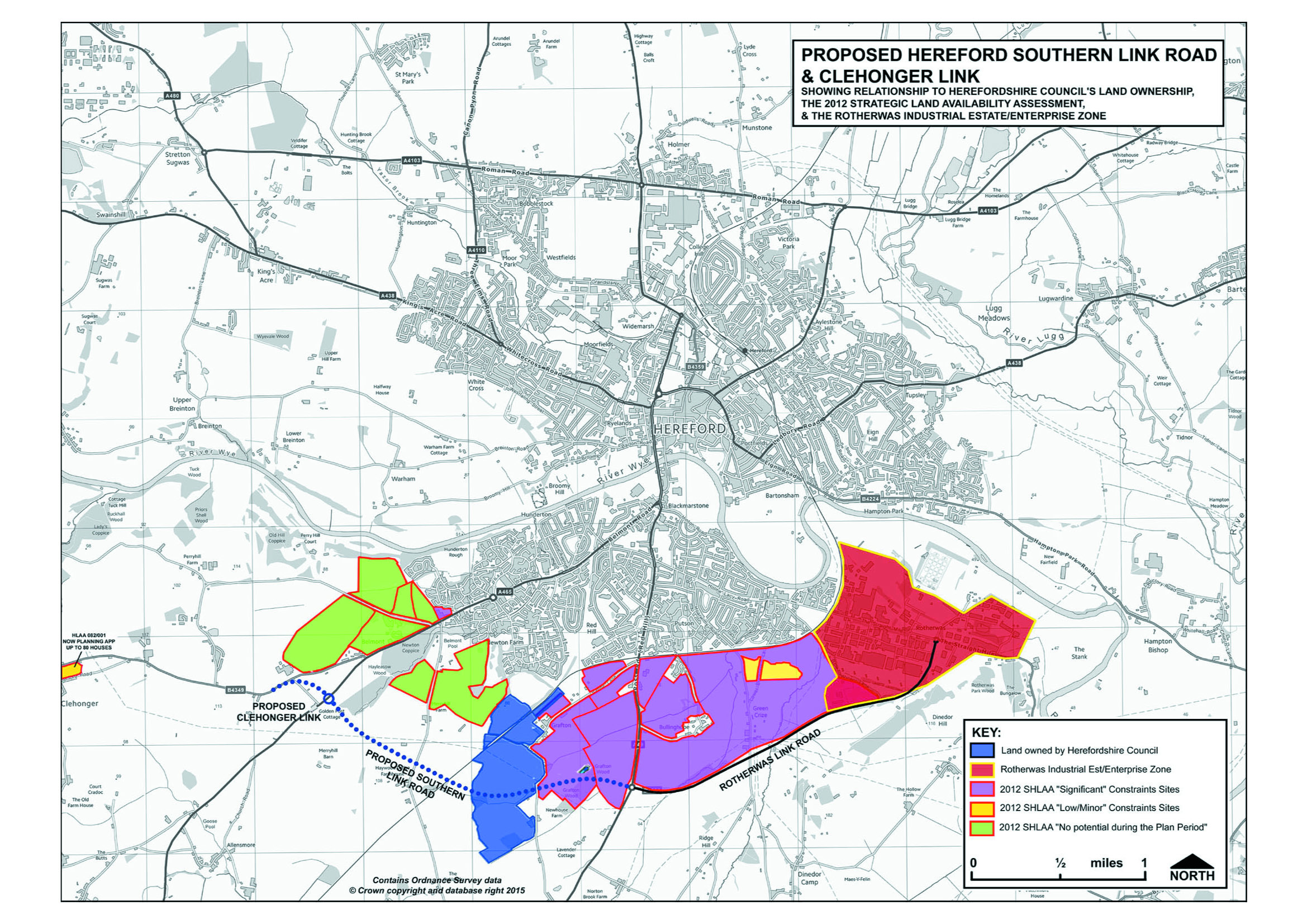
THIS MAP SHOWS: The Southern Link Road and Potential Housing Development sites from the Strategic Housing Land Availability Assessment (SHLAA).
THE MARCHES LEP AND HEREFORDSHIRE COUNCIL STATE THAT THE SOUTHERN LINK ROAD WILL ‘UNLOCK LAND FOR HOUSING’. THIS CAN ONLY BE TRUE IF THERE IS GOING TO BE SIGNIFICANT HOUSING DEVELOPMENT NEAR THE SOUTHERN LINK ROAD WHICH HAS NOT YET BEEN REVEALED.
We have provided this information to show:-
a. The Southern Link Road (and Rotherwas Link/Access Road) act as “Distributor” Roads to open up land for significant housing around Hereford.
b. Using an average housing density of 35 dwellings per Hectare (the Core Strategy
Southern Urban Expansion density), and applying that to the SHLAA land
areas, the total potential for houses on the SHLAA sites would be 12,705.
c. The Southern Link Road traverse the small holding land in Herefordshire Council’s ownership which could deliver a further 2,310 homes. Total housing potential is 15,015.
d. The number of houses assigned to the Southern Urban Expansion in the
Core Strategy is 1,000 MINIMUM. So the 14,015 house building potential is currently not explicit in any plan. However, the total number of houses to be delivered for Hereford is a minimum of 6,500 to 2031. With Herefordshire Council needing the new Homes Bonus to fund the Southern Link Road expect delivery of new house building within the Southern Link Road area.
d. Traffic from these houses will still need to access Hereford for work, schools, hospitals or shopping so do not be fooled by claims that a Relief Road will enable that. 85% of traffic in Hereford is “internal” i.e. starting and finishing journeys within the City. Any so-called ‘Relief Road’ will not go into Hereford.
e. The “constraints” which could prevent delivery on these SHLAA sites are likely to disappear under the Core Strategy and the National Planning Policy Framework rules.
f. There is currently a 2015 “call for sites” underway by
Herefordshire Council with developers and land owners to update the 2012 SHLAA. When this becomes publicly available we will publish an updated map.
If you would like to respond to the planning application for the Southern Link Road:-
1.write to Ms Kelly Gibbons, Planning Dept, PO Box 230, Blueschool House, Blueschool Street, Hereford. HR1 2ZB. (Tel 01432 261781).
2. Or email her at kgibbons@herefordshire.gov.uk
3. Copy in your ward councillor (contact details can be found here )
In any correspondence include the planning application reference given at the top of this page P151314/F.