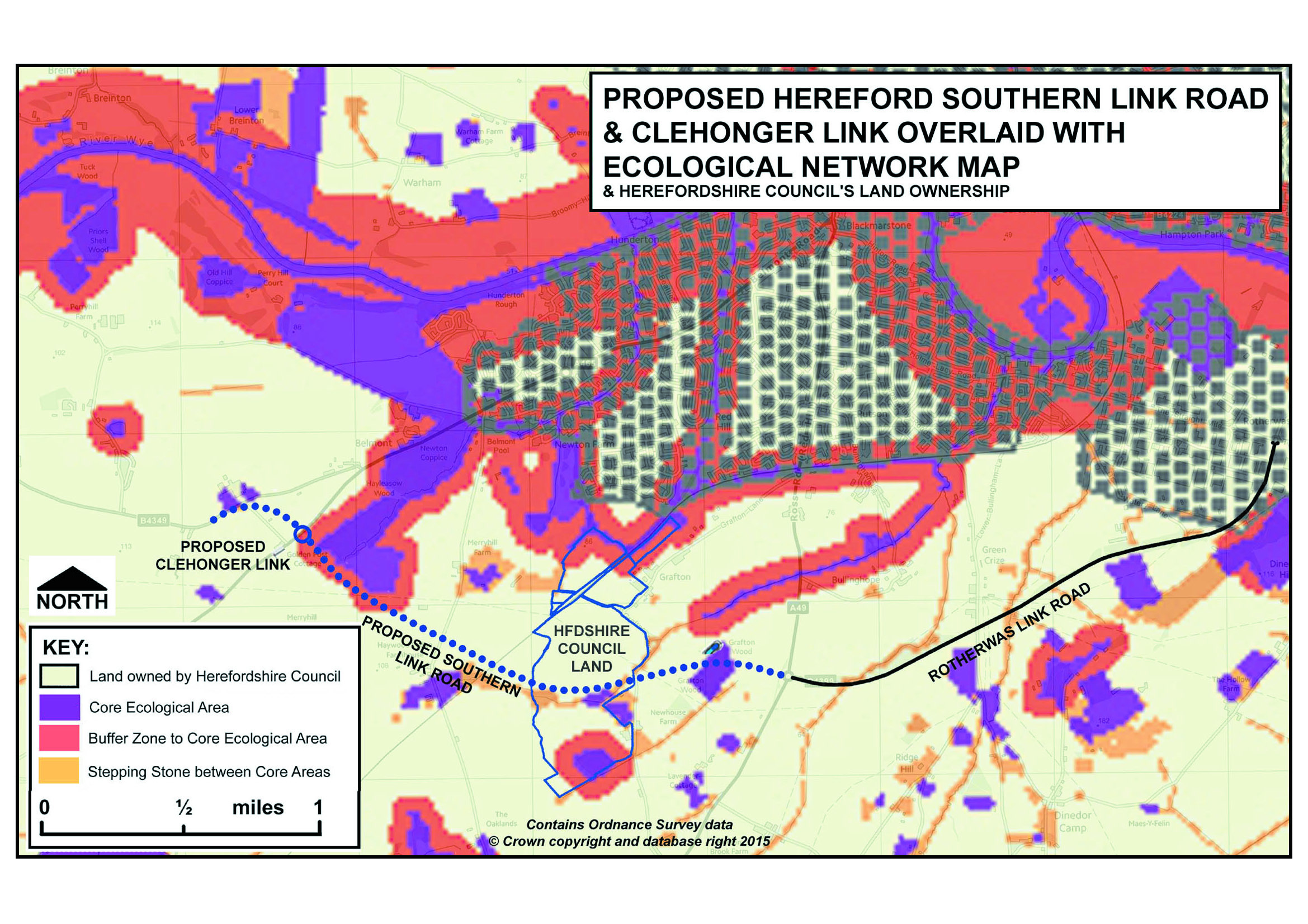
This map shows the proposed Hereford Southern Link Road and Clehonger Link overlaid with the “Ecological Network” map produce in 2013 by Herefordshire Council.It also shows the Herefordshire Council Land ownership.
The Ecological Network map is part of the Core Strategy Local Plan which states (para 5.3.16) “Development within and adjacent to these core areas and associated
buffer zones will need to be sympathetically designed to ensure there are
no adverse impacts upon them.” Note the “NO ADVERSE IMPACTS”. The map is somewhat limited as it does not necessarily include all important sites and linkages. For example, the footpath between Grafton Wood and the A49 should qualify as a wildlife corridor, as it is clearly an ancient track with old hedges on both sides, and a clear ancient boundary bank on one side.
Despite its limitations in showing the minimum recorded ecology in the area of the Southern Link Road, please note the following on this map:-
- Grafton Wood is in the Ecological Network Map as a Core Area (bisected by
the proposed road), as is the woodland to the east of the proposed A465
roundabout which is Newton Coppice, also Ancient Woodland. (Note: Ancient
Woodland is “irreplaceable” re para 118 National Planning Policy Framework ). - The proposed road (and the roundabout) traverses the Buffer Zone along the whole length of the south-western edge of Newton Coppice/Hayleasow Wood.
- There are also fragile “Stepping Stone” corridors in this area and one of those is breached by the proposed road north of Veddoes Farm. The blue lines signify Herefordshire Council’s land ownership so the proposed breaches are on Council land. This is important, though, because currently these ecological corridors come down from the north-east, connect with the Core Areas and Buffer Zones north of Veddoes Farm, and link to a further Stepping Stone which goes north-east back to the Ancient Woodland of Grafton Wood.
- In respect of ecological networks, the National Planning Policy Framework states (para 109) “The planning system should contribute to and enhance the natural and local environment by minimising impacts on biodiversity and providing net gains in biodiversity where possible, contributing to the Government’s commitment to halt the overall decline in biodiversity, including by establishing coherent ecological networks that are more resilient to current and future pressures.”
- The proposed road will reduce the resilience of the natural and local environment, not just through the direct destruction of ancient woodland; wildlife habitats; loss of high grade soils (which contain 25% of the world’s biodiversity) but by destroying the ecological networks shown above.
- The area proposed for “mitigation” for the loss of ancient woodland by the A49 and Grafton, will initially be used as storage for building supplies, heavy plant, etc.. This will destroy the ancient features, compact and contaminate the high grade soil prior, making the “mitigation wood” liable to fail. By then the ancient woodland will have been destroyed and the biodiversity and wildlife lost.
THE SOUTHERN LINK ROAD CANNOT CONCEIVABLY HAVE “NO ADVERSE IMPACT” UPON THE CORE ECOLOGICAL AREAS & BUFFER ZONES. IT IS CONTRARY TO THE NATIONAL PLANNING POLICY FRAMEWORK BY REDUCING ECOLOGICAL RESILIENCE.
Since 2013 there has been no funding for any staff to record and maintain the evidence of the range of animals, plants and organisms that live and breathe alongside us in our beautiful County.
The Ecological Network Map is not easy to decipher and is low resolution but by spending hours keying it to base mapping, and boosting the resolution, it is possible to localise the map. Here for Hereford would like to express thanks to a member who has made this map available and overlaid it with the route of the proposed Southern Link Road. The alternative would have been to spend £150 for the Herefordshire Biological Records Centre to prepare a legible localised copy.